STUDY SYSTEMS
We work at a variety of study sites around Ireland, and via links with our international collaborators, in study systems in the UK, mainland Europe and Canada.
The Burrishoole Catchment, County Mayo, Ireland
We work at a variety of study sites around Ireland, and via links with our international collaborators, in study systems in the UK, mainland Europe and Canada.
The Burrishoole Catchment, County Mayo, Ireland
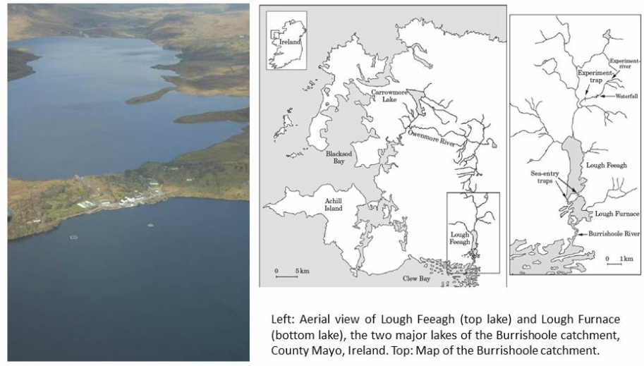
The Marine Institute of Ireland Research station is located in the Burrishoole catchment near Newport in Co Mayo. It is a site for integrated research into freshwater and brackish ecosystems and their interaction with climate and the environment, and two members of our group (Phillip McGinnity and Tom Reed) are based at the station.
Burrishoole is situated close to the Atlantic coast and has a temperate oceanic climate. Average annual rainfall at the meteorological station on the eastern shore of Lough Furnace is 1560 mm/year while mean summer and winter water temperatures are 15°C and 6°C, respectively. The Burrishoole system consists of some 45km of rivers and streams, which are all very spate-like in nature, rapidly rising and falling in response to precipitation. These rivers drain into Lough Feeagh, the largest freshwater lake of the catchment (320 ha, top lake in above figure). Two outlets from Lough Feeagh feed the tidal Lough Furnace (141 ha, bottom lake in above figure), both of which have permanent upstream and downstream trapping facilities maintained by the Marine Institute, for counting fish migrating between the sea and freshwater. Lough Furnace then flows into Clew Bay.
The Marine Institute’s facility at Burrishoole is an international index site for the diadromous species Atlantic salmon (Salmo salar), brown trout (Salmo trutta) and the eel (Anguilla anguilla). Other fish species present in the Burrishoole catchment are the Arctic charr (Salvelinus alpinus) and three spined stickleback (Gasterosteus aculeatus). In addition to the fish-stock monitoring programme, a comprehensive environmental monitoring network exists (Whelan et al. 1998). Total trapping of downstream salmon and sea trout smolt migrations have been carried out on the Burrishoole system since 1970. The traps have enabled a census of all migratory salmonid movements upstream and downstream since 1971 (Poole et al. 1996). For up-to-date data on fish counts and environmental/meteorological data, see here.
The Burrishoole system has a run of both grilse or 1 sea-winter (1SW) and 2 sea-winter (2SW) salmon. There is only a small multi-sea winter component in the Burrishoole stock, normally <10% of the total run, which has not exceeded 100 fish since the early 1960s. The numbers of Atlantic salmon recorded in the upstream traps since full trapping commenced in the 1970s have fluctuated from a high of 1,777 in 1973 to a low of 252 in 1990. Annual escapement to freshwater is known to have been influenced by both the level of exploitation in the coastal drift net fishery and fluctuation of marine survival to the coast. Following the cessation of this fishery in 2007, a marked increase in the numbers of fish returning to the catchment was recorded in that year. However, this increase occurred only in 2007, with numbers in 2008 and 2009 falling to levels similar to those recorded prior to the cessation of drift netting. This fall in numbers would indicate a probable decrease in marine survival in line with the reported downward trend in pre-fishery abundance for Irish populations in general (Peyronnet et al., 2007).
The Marine Institute of Ireland operates an experimental captive breeding and smolt release (ranching) programme at Burrishoole. The captive breeding programme for salmon was established from wild fish collected from the catchment between 1960 and 1964. Additional wild fish were included in the breeding stock between 1970 and 1975. The breeding population has been effectively closed since that time with brood fish being selected from returning ranched fish.
References:
Peyronnet, A., Friedland, K. D. & Ó Maoiléidigh, N. 2008. Different ocean and climate factors control the marine survival of wild and hatchery Atlantic salmon Salmo salar in the north-east Atlantic Ocean. Journal of Fish Biology, 73, 945-962.
Poole, W.R. & Reynolds, J.D. 1996. Age and growth of yellow eel, Anguilla anguilla (L), determined by two different methods. Ecology of Freshwater Fish, 5(2); 86-95.
Whelan, K.F., Poole, W.R., McGinnity, P., Rogan, R. & Cotter, D. 1998. The Burrishoole System. Chapter 11. In: Ed. Moriarty, C. Studies of Irish Rivers and Lakes Marine Institute, Dublin. Congress of Societas Internationalis Limnologiae (SIL), Dublin .279pp
Other study systems in Ireland:
The Shannon River system
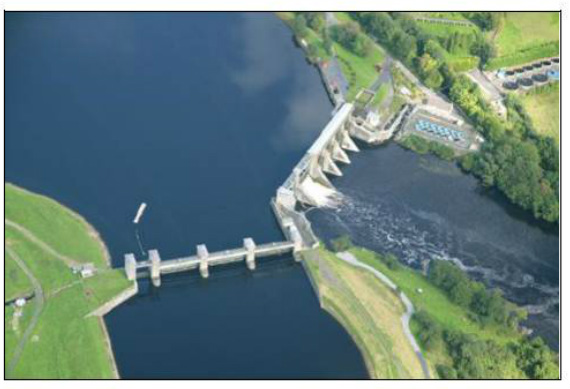
An ongoing project is investigating restoration ecology issues in the Shannon River system. Click here for more details. The above figure shows the hydroelectric dam and smolt rearing facility at Parteen on the River Shannon.
The River Moy, County Mayo, Ireland.
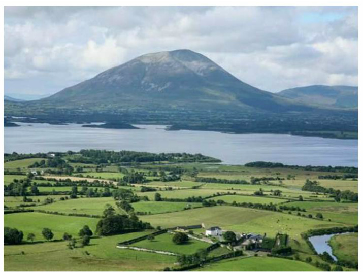
Above: Lough Conn, the main landscape determinant of Atlantic salmon (Salmo salar) population structure of in the River Moy system, Co. Mayo. For more details on landscape genetics studies in the River Moy system, see here.
